Annals of Environmental Science and Ecology

Archive Articles

Article Image 1

Disastrous Effects of Hurricane Helene in the Southern Appalachian Mountains Including a Review of Mechanisms Producing Extreme Rainfall

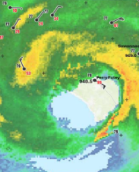
Hurricane Helene made landfall near Perry (Latitude 30.1N) in the Big Bend area of Florida with a central pressure of 939hPa. It moved northwards creating devastating damage and loss of life; however, the greatest damage and number of fatalities occurred well to the north around the City of Ashville (Latitude 35.6N) where extreme rainfall fell and some of the strongest wind gusts were reported [1-3]. This paper describes the change in the hurricane’s structure as it tracked northwards, how it gathered tropical moisture from the Atlantic and a turning wind profile between the 850hPa and 500hPa elevations which led to such extreme rainfall. This turning wind profile is shown to be associated with extreme rainfall and loss of life from drowning and landslides around the globe. The area around Ashville suffered 157 fatalities which is a significant proportion of the 250 fatalities so far recorded in the whole United Stares from Helene. This is of extreme concern and should be investigated in detail as the public generally expect the greatest impact from hurricanes to be confined to coastal areas near the landfall site. It is another example of increased death tolls from tropical cyclones moving inland and generating heavy rainfall. As the global population increases and inland centres become more urbanised, run off from such rainfall increases which causes greater devastation.

Jeff Callaghan*


Article Image 1

Evaluating Changes in Contaminants of Emerging Concern in Municipal Wastewater Effluents Following Treatment Plant Upgrades

Contaminants of emerging concern (CEC) are known to affect aquatic organisms downstream of wastewater treatment plant effluent discharges. Studies in the Grand River watershed on the small-bodied, benthic rainbow darter (Etheostoma caeruleum) have shown altered gene expression, sex steroid levels, gonad size and expression of intersex (testis-ova) associated with wastewater outfalls. Due to these observed biological impacts, over $450M has been spent by the municipal government to upgrade the two major wastewater treatment plants (WWTP) within the Grand River watershed (Waterloo, Kitchener). In this study we monitored process upgrades at each of the WWTPs between 2010 to 2019 for a suite of chemicals including nutrients, CECs, hormones and total estrogenicity. Effluent samples for select CECs and total estrogenicity were analyzed by LC-MS/MS and yeast estrogen screen (YES) assay, respectively. Estrogenicity of the effluent declined rapidly after upgrades were completed. The removal of key CECs varied depending on their physiochemical properties. Although treatment process upgrades lead to greatly reduced environmental exposure to many CECs such as naproxen, some remain at relatively high concentrations (i. e. carbamazepine) that may continue to represent a risk to the environment.

Nivetha Srikanthan1 , Azar Fattahi1*, E. Katie McCann1 , Leslie M. Bragg1 , Hadi Dhiyebi1 , Diana M. Cardenas-Soraca1 , Pam Law2 , Dominika Celmer-Repin2 , Sonya Kleywegt3 , Wayne J. Parker1 and Mark R. Servos1


Article Image 1

Elimination of Urinary Fluoride in the Population of Diamaré in Relation to Water Contamination

Introduction: Fluorosis, also known as fluorine poisoning is a disease caused by the disruption of various metabolic pathways, one of which includes calcium metabolism implicated in dental and bone formation due to the replacement of calcium by fluoride ions in bone matrix. The aim of study was to determine the presence of fluorine of the population consuming water contaminated at the Diamaré Division.

Method: A cross sectional analytic study design in 7 villages at the Diamaré division from 1st December 2021 to 30th May 2022 was carried out. Participants who gave consent and filled the selection criteria were included. The socio-demographic characteristics, medical history, eating habits and clinical characteristics of the participants were obtained using a questionnaire. Samples of urine, blood of participants and water were collected for analysis at the Centre for Study and Control of Communicable Diseases at the Faculty of Medicine and Biomedical Sciences of the University of Yaoundé. Fluoride concentration in water and urine. Data entry and analysis was done using Epi info; Associations were derived from bivariate analysis.

Results: We had bore holes, wells and river as water sources used of water for drinking, cooking and household activities. 152 participants were recruited and the most common water source used was bore holes (N=94; 61.84.7%). Some used water from one source only; others from two sources or more. Majority had Joint pains (78.7%). Dental fluorosis accounted for 26%., bowed legs 4.7%, skeletal deformities 6%, immobilization of joints 41.3% and knocked knees 1.3%. A mean water fluoride concentration of 1.30 ±1.68mg/l ranging from 0.04-5.75mg/l was obtained from 30 samples of water collected while that of 2.89 ±2.87mg/l ranging from 0.05-14.35 mg/l was obtained from urine.

Conclusion: The majority of water sources (wells and boreholes) used by our study population for consumption are contaminated with fluoride which is eliminated in urine by the entire population.

Antoine Vayaraï MANAODA1*, SAMIRA Amadou2, YINYANG Jacques1, NGOULE Charles2, ETAME LOE Giselle2 and ADIOGO Dieudonné1


Article Image 1

Assessing Environmental and Pharmaceutical Vulnerability Using NDVI: A Case Study of the EF-3 Tornado in Rocky Mount, North Carolina

On July 19, 2023, an EF-3 tornado struck Rocky Mount, North Carolina, severely impacting the environment and damaging Pfizer’s pharmaceutical facility. This project uses the Normalized Difference Vegetation Index (NDVI) to analyze environmental vulnerability before and after the tornado. Landsat 8 satellite imagery was used to compare NDVI data from two weeks before and four weeks after the event. Using ArcGIS, zonal statistics and raster analysis identified areas of significant vegetation loss across urban, forested, and agricultural zones along the 16-mile tornado path. Results revealed notable decreases in NDVI values, indicating widespread loss of vegetation and soil disruption. Damage to the Pfizer plant, which produces about 25% of U.S.hospital-injectable medicines, emphasized the tornado’s critical pharmaceutical impact. This study demonstrates how geospatial science tools like NDVI can assess environmental vulnerability and disaster impact, helping guide future planning, emergency response, and infrastructure resilience in a changing climate.

Keywords: EF-3 Tornado; Environmental Impact; Geospatial Analysis; Disaster Resilience; Vegetation change.

Logan McNeil, Daniel Chu and Rajendra Nath Dasari*